Wamuran Queensland, 4512
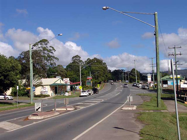
Wamuran is a very pretty farming town with a growing residential and rural residential population. It is situated on the D’Aguilar Highway in the Moreton Bay Shire, 60 km north-west of Brisbane & 11 kilometers west of Caboolture. The fertile, undulating landscape is in the hinterland with the D’Aguilar Range to the west and the Glasshouse Mountains to the north. Wamuran is 200 ft (61 m) above sea level with a comfortable and temperate year round climate and an average annual rainfall of 1,270 ml. A steadily growing population – 285 (1961 census), 779 (1996 Census) & 2,086 (2006 Census) ensures the viability and potential growth of the area
Wamuran is a large fruit-growing district, “The Fruit Salad Bowl of the Sunshine Coast”, with bananas, lychees, pineapples, strawberries, citrus, avocadoes, pawpaws, custard apples, passionfruit, tropical stone fruit, pecan & Queensland nuts, along many other tropical and exotic fruits. Beef cattle, horses, llamas and alpacas and, lately, turf production complement the fruit industry. One of the early sawmills still remains open and working today.
Wamuran is a great place in which to live. There is a strong community involvement with many volunteer groups. This was community spirit was recognised in 2006 with the awarding of the “Regional Bush Spirit Award” in the Queensland Tidy Towns Competition. These community groups include:
Wamuran and District Men’s Shed is a recently formed and very active Men’s, and Women’s, Shed based at the Old Wamuran School.
The Wamuran Sporting Association in Campbell’s Pocket Road. Actively used by many affiliated clubs including Cricket, Netball, Tennis, Little Athletics, Hockey, and Boxing. This Association now has a great clubhouse, and beautifully kept and well used grounds.
Wamuran Neighbourhood Watch was formed in 1990 and all these years later is still going strong, staying in contact with a monthly community newsletter written and printed by volunteers.
The Wamuran Community Hall was opened in April 1985, replacing the old Albert Hall which was built in 1921. Many functions and activities are held in the hall with the regular Wamuran Dance still being held on the 4th Saturday of each month at 8 pm. Dances have been held in the hall for many decades.
Wamuran Co-operative, now Suncoast Rural is a large and locally very important 75 year old business that caters for this diverse farming community. The Co-op offers a complete rural package with general farming and hardware lines, not only for the farmers but for all rural residents.
Wamuran Rural Fire Brigade is an active and necessary part of the local community. The Wamuran RFB has been in existence since the 1940’s and is now equipped with modern appliances and equipment and a willing and competent volunteer crew.
Wamuran Indoor Bowls began in the Wamuran Hall in 1965 and continues to this day. Come along for a game every Tuesday morning
Wamuran State School, like most rural schools, is the centre of the community and is involved in many community activities, including Anzac Day & Remembrance Day Services.
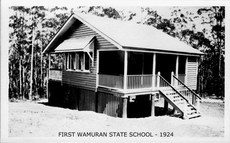
Wamuran Historical & Visitor’s Centre Inc. The original Old Wamuran School, now situated in the Wamuran Hall grounds, is used for community purposes, including, on Wednesdays, a Pre-Loved Book Sale and a Community Craft Friendship Day. The old building is open for inspection and Books and Craft items are for sale during the Wamuran Country Markets on Saturday mornings. This 1921 building has been restored and is now known as the Wamuran Historical & Visitors Centre. Local history details and historical photos are being gathered to hang in the building as a permanent display.
Wamuran Country Markets are run on the 4th Saturday mornings from 7am to 12 noon in the Wamuran Hall grounds and in Old School. The markets feature a variety of stalls including crafts, local fruit and veg.,plants, Devonshire teas, sausage sizzle and all sorts of esoteric things to cater for all tastes. The BBQ is operated by volunteers and is a very popular meeting place.
Places of Interest in and around Wamuran
Wamuran National Servicemen’s Memorial Park is situated opposite the IGA and Wamuran Hall on D’Aguilar Highway, Wamuran, with picnic tables, seating, 2 BBQ’s & swings and a children’s play area.
“Heritage Harvest” sculpture is situated in front of the Wamuran Hall on D’Aguilar Highway, opposite the IGA and National Servicemen’s Park. A local sculptor, Guy Robinson of Woodford, was commissioned in 2008 to this historical sculpture. This carving of Helidon sandstone, named “Heritage Harvest” portrays the history of Wamuran area. Stylised trees represent the dense forest used for timber-getting, a horse drags a sled loaded with local produce – bananas, strawberries and pineapples; the sled was preferred to wagons which were more likely to ‘escape’ down the mountain slopes.
The other side of the sculpture block depicts a PB15 locomotive, which was a common sight on the Wamuran rail line, pulling produce and passengers. Guy, the artist, was assisted by the members of the Railway Workshops Museum to ensure the accuracy of representation of the PB15. Railway buffs may be interested in checking out Guy’s representation of the Stephenson valve gear. This sculpture was unveiled at the Wamuran Q150 Celebration – ‘Wamuran’s people, places and stories.’ in August 2009.
The Historic Site at Jackson Park, in Basin Road (off Campbell’s Pocket Road), Wamuran. This is the site of an old stone camp oven used by the Anderson family in 1870’s during talks with the local aboriginals of the Wamuran Basin. The Andersons were one of the 4 families to settle in Wamuran in 1872/73. It has been said that the rainforest was so dense in those early days that their young children needed to be tethered to trees so they couldn’t get lost whilst these talks were taking place. Unfortunately, very little virgin rainforest still exists in the Basin area as the area was cleared, many years ago, for maize and later for dairy cattle.
The Wamuran Rail Trail is an attractive and scenic track used for hiking, horse or bicycle riding. Starting at the gate at the dead-end of Mylett Road the gate is marked with a TRAIL sign. The Rail Trail is actually part of the “Wamuran Loop Trail” (28km), which is maintained by Moreton Bay Council This Trail runs through the forest from Raaens Road and then takes in a short section of the former railway corridor beside the highway, west of Wamuran. The closed railway corridor from Caboolture to Wamuran is now officially part of this trail
Link – http://www.railtrails.org.au/states/trails.php3?action=trail&trail=108
A Scenic Drive

This is beautiful round trip drive gives you the opportunity to take in some of the scenic wonders of Wamuran, Wamuran Basin and neighbouring Mt. Mee.
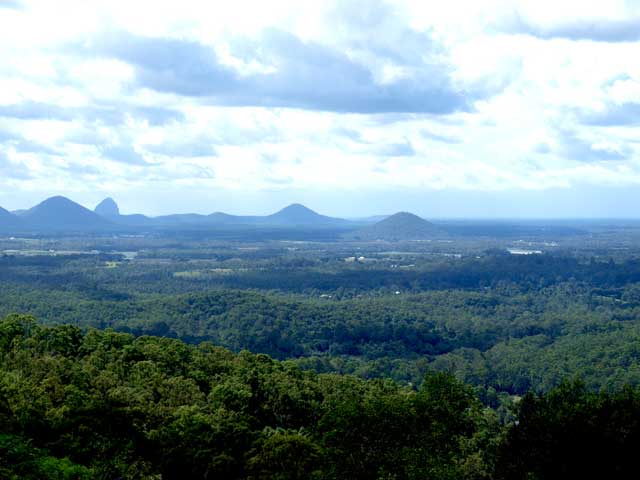
Directions: From Wamuran township drive down Campbell’s Pocket Road, until you come to Basin Road on your right, just over the second bridge. Drive down Basin Road until you come to Jackson Park, check out the historical site there and have a walk around the creek. Then drive a little further along Basin Road and turn right into Samson Road, and just up the hill turn the car around. The view of the Basin from there is just lovely! Then back-track to Campbell’s Pocket Road, turn right and head off up the hill. Find somewhere to pull over at the top and look back over Wamuran, the Glasshouse Mountains & Moreton Bay. Continue up Campbell’s Pocket Road until you come to Bass Road on your left. Drive to the end of Bass Road – the panoramic view from here is beautiful! Drive back to Campbell’s Pocket Rd, turn left and continue until you come to a T junction, turn right on to Mt. Mee Road, noting the view on the left across the ranges; and stop further along at the Mt. Mee Lookout (well sign posted) on your right. Now, that view is something else, especially on a clear day. The view takes in Redcliffe to Caloundra and further north, Moreton Bay, all of the Glasshouse Mountains, and all the towns and farming lands around to the east and north. Continue down the Mt. Mee Road to D’Aguilar, turn right onto D’Aguilar Highway and drive back to Wamuran.
Other interesting drives
1. Round trip through Mt. Mee State Forest.
Directions: Drive west along Campbell’s Pocket Road and turn right into Topyard Road, along which you get a great view over the Wamuran Basin and out to Moreton Bay. While there, turn right at the end of the road into Pedwell Road, and drive up the road a little way to take in another breath-taking view looking south – over the Basin and out to Moreton Bay. Pedwell Road is a dead end road, so turn around again and retrace your steps back to Wamuran, or continue west along Pedwell Road until you reach Mt. Mee Road. Turn left and continue along Mt. Mee road for a few kilometres until you see the signpost to Mt. Mee State Forest on your right. This, again, is a beautiful drive and it eventually opens up to a lovely picnic grounds with tables and BBQ’s (and plenty of goannas), with a huge old mill gantry to visit. There is a camping area off to the left, past the picnic area. After a cuppa or picnic, return to Wamuran, or continue south along the Mt. Mee Road to Dayboro, driving back to Wamuran via Strathpine.
2. Raaen’s Road off the D’Aguilar Highway at D’Aguilar at the top of the range has some wonderful views, but this is a rough dirt road that leads back to Twin View Road & Newlands Road in the northern area of Wamuran. Parts of this road are best traversed using a 4WD.
3. Another great drive to see the farming lands and the Glasshouse Mountains up close, and other interesting sights around Wamuran.
Directions: Turn off the D’Aguilar Highway opposite the IGA, turn right after the rail line and left at the next corner. You should now be on Newlands Road heading north. Turn left into O’Shea Road, the 2nd road on your left, drive along there for 1 km or so, and you should have a strawberry farm on your right, and on your left is a beautiful view across the valley with strawberry and pineapple farms and fruit orchards and D’Aguilar Range in the back ground. This is a particularly beautiful site at sunset, with reflections of the setting sun off the dam at the bottom of the hill. Turn around and drive back to Newlands Road and turn left and continue to head north. Take the next turn to your left (Patane Road), continue down there and once you pass the corner, it becomes McClintock Road, where you’ll have stone fruit and other trees on your left. Continue and turn left into Derrick Road, and right into McConnell Road, and left into Woodlands Drive. At the end of Woodlands Drive (at the pine forest), turn right and then right again into Atkinson Road. This will lead you back to Newlands Rd. Turn left into Newlands Road, then right into Powell Road, note the huge Turf Farm and Pinata Packing Shed on you left, and right into Pates Road (at the crossroads), travelling past more pineapples and turf farms, left into Newlands Road, and this will lead you back to town – a beautiful drive that shows the true diversity of farming in the area.
